
From routeinfo.no, navigators can download quality-assured sailing routes for navigation, as well as important voyage-related information ‒ free of charge. The service will make the navigator's route planning easier and less time-consuming, and could reduce the risk of unfortunate route choices. In the near future, the service will also include quality-assured sailing routes for Svalbard in the High North.
A risk reducing measure
In order to reduce the risk of hazardous meeting situations between vessels, the routes are separated from the opposite direction where possible. Today, this type of traffic situations is a challenge in particularly narrow and difficult fairways.
“The main purpose of the service is to reduce the number of ship accidents. We want fewer groundings and unfortunate meeting situations at sea. Therefore, we want vessels to sail starboard, and not use the same route of inbound and outbound voyages,” says project manager and senior engineer John Morten Klingsheim in the department of navigation technology and pilotage management at the Norwegian Coastal Administration.
The more than 600 sailing routes are quality-assured by the Norwegian Coastal Administration's pilotage service, Vessel Traffic Service (VTS), Aids to Navigation Service and Pilot Exemption Certificate Unit. The route’s depths data are also checked by the Norwegian Mapping Authority's Sea Division.
Data from different sources presented in one digital service
From routeinfo.no, navigators can download sailing routes directly into the navigation system on board all utility vessels that support the 2015 standard for chart systems. The route will be a reference route for planning the voyage, but must be adapted to the vessel and the voyage. The routes are quality-assured for vessels up to 150 meters in length and nine meters in depth, with some exceptions.
The Norwegian Coastal Administration has gathered different information about the voyage in one digital service. This is information that is currently scattered in various maps and publications. Routeinfo.no provides access to:
- local regulations on, among other things, bans on meeting traffic in narrow fairways, and visibility and size restrictions for vessels,
- quay and port locations,
- sailing distances,
- VHF channels for communication in risk areas where the Norwegian Coastal Administration's Vessel Traffic Service centres monitor and organize ship traffic.
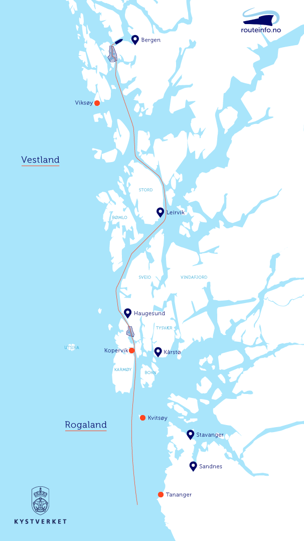
Route illustration
Many benefits
Klingsheim points to several possible benefits, including a time-saving effect.
“Preliminary studies show that navigators could save 20-30 percent in time on route planning by using our service, and that includes navigators of course getting acquainted with other information in the ship’s navigation system prior to departure”.
In addition, it could have an environmental benefit, as navigators based on the routes can calculate the estimated arrival time and thereby reduce their fuel consumption ‒ so-called just-in-time arrival. This is especially relevant for vessels that book pilots and who often have limited knowledge of the route to the relevant port and quay.
Experience so far shows that the service also contributes to better interaction between vessels and the Norwegian Coastal Administration's pilotage service and Vessel Traffic Service (VTS).
A preventive measure
In the Maritime Safety Analysis 2014, the sharing of sailing routes and route information is identified as an important measure to:
- reduce the complexity of work tasks for bridge crews,
- help make the traffic overview more predictable and easier to understand, and
- reduce the risk of errors or misjudgment.
The digital route service routeinfo.no is part of the Norwegian Coastal Administration's streamlining and digitization of maritime services. The service offers sailing routes to all major ports between Halden in the south and Kirkenes in the north. Soon, sailing routes on Svalbard will also be included in the service.
“We work to give everyone at sea effective access to correct information. The use of digital sailing routes along the coast will strengthen and simplify the interaction between ships and the Norwegian Coastal Administration's pilotage service and Vessel Traffic Service. This is in line with the international e-navigation strategy, where simplification and streamlining of the information flow between ships and authorities is an important measure,” says director of navigation technology and maritime services Arve Dimmen at the Norwegian Coastal Administration.
“With a good collaboration with the Norwegian Mapping Authority, the Norwegian Meteorological Institute and others responsible for navigation services, including the Norwegian maritime cluster, we believe the service is a right step on the way forward in our joint work for safe, efficient and sustainable sea transport,” Dimmen points out .
Click here to read more about the routeinfo service
